a_area Struct Reference
Area.
More...
#include <world.h>
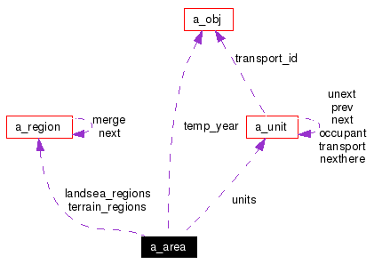
Collaboration diagram for a_area:
 [legend]List of all members.
Detailed Description
Area.
An "area" is always basically a rectangular array of positions. The hex effect can be achieved by interpreting neighborliness and direction differently, but that's all that's needed. All of the "layers" are dynamically allocated as needed, to save (considerable!) space.
See the discussion of layers for a more complet discussion of the various types of layers.
Member Data Documentation
|
|
vector of extra types layer |
|
|
calculated average of elevations layer |
|
|
altitudes of clouds of cloud layer layer |
|
|
heights of clouds in the cloud layer layer |
|
|
types of clouds in the layer layer |
|
|
the side actually in charge layer |
|
|
layer of elevations layer |
|
|
layer of ids of features layer |
|
|
height of the area being used for data |
|
|
width of the area being used for data |
|
|
x offset within full area to get data from |
|
|
y offset within full area to get data from |
|
|
Pointers to the various "layers". |
|
|
Region list. Area is devided into land and sea. layer |
|
|
position within whole world |
|
|
position within whole world |
|
|
layer of materials in each cell layer |
|
|
calculated min/max of elevations layer |
|
|
calculated min/max of elevations layer |
|
|
the overt side alignment of the locals layer |
|
|
Isometric projection flag. ??? |
|
|
x location at which sun is overhead |
|
|
y location at which sun is overhead |
|
|
cycle of temperatures within year |
|
|
layer of cell temperatures layer |
|
|
terrain type at this spot layer |
|
|
Region list. Area is divided by terrain types. layer |
|
|
pointer to units if any layer |
|
|
IDs of units using materials in each cell layer |
|
|
layer of force/dir of winds. layer |
|
|
true if x coords wrap around |
The documentation for this struct was generated from the following file:
Generated on Sat Sep 17 10:29:49 2005 for XconqKernel by
 1.3.6
1.3.6


 1.3.6
1.3.6